Japan Tropical Microcontinent
Revision as of 04:49, 27 November 2013 by Anaimfinity Resident (talk | contribs) (Created page with "200px|thumb|right|Map A142 is the temporary name given to this Microcontinent by the ''Second Life Geography'' team. It has [[Coordi…")
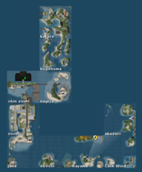
A142 is the temporary name given to this Microcontinent by the Second Life Geography team. It has Coordinates 879-883/1048-1052, that places it inside Grid Sector H10, Western Ocean. It is West to Caledon - Winterfel and North to Uhre Continent.
The microcontinent is composed of 10 sims. On the map, they take an interesting form of a hook. Usually, altitude is low and more then half of the land is covered by Water. The sims have Japanese names. In North, islands are larger then in South. The central part is more diferent because it has suspended roads. Another road is visible in East. There are a few ports on other sims.
Not all parcels have access for public.
