Snowlands Subcontinent
NOTE: THIS ARTICLE IS UNFINISHED. ESTIMATED FINISH DATE: JANUARY 1ST 2014
Snowlands is a Subcontinent located in Sansara. It is not the only place on the grid where Snow & Snowlands are found, but certainly is the largest one and the most known. Hundreds of pages have been written about Sansara and its snowlands. This article is written from a strict Geographic point of view. It reflects the situation of Snowlands in December 2013 and also it is written in a similar way to a touristic guide.
Geography
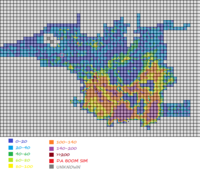
Snowlands cover a large surface and have one of the most interesting Geographic structures. Also, there are some transition areas. Here are all peaks higher then 200 meters on Sansara.
Main Snowlands
This includes the permanently ice-covered land. Everything here is white. It can be divided in 3 separated places: Chamonix, North snowlands and South Snowlands.
Chamonix is a peninsula to West, formed of 6 sims. It is a winter village.
North Snowlands are built with interesting Geographic features. There are many rivers. Interesting is that water is actually coming from Sutherland Abyss (see Dams for more information) and water altitude drops from sim to sim, creating waterfalls. Part of this water is navigable, part not. In Zermatt sim water is complete frozen, so you can walk along it. Altitude is usually lower, but that is not a rule. Declivity is very high. In fact, many mountain peaks have more then 200 meters high (see Altitude for a list). These very sharp peaks were detected by the drone that made altitude maps for Sansara. Results were unexpected, in contradiction with average values found anywhere else on the continent. There are also many lower places. Geographic fragmentation is very high.
South Snowlands are less differentiated and have some common features with all South Sansara. Large part is a high plateau. Altitude is high, but never reaches 200 meters. Average altitude is higher in South then in North, even if highest mountains are found in North and not in South. There are not many rivers. In South, oceanic shore can be visited (but it is not a good place for sailing).
Transition Land
This includes places close to the snowlands.
Tundra is found in East and in North. It is a place that is covered with permafrost. Vegetation is less developed and the influence from colder snowlands is visible. Usually, the tundra is in contact with river or oceanic water. Altitudes are high.
North Mountains are a a high natural obstacle between cold air from snowlands and warm air from the old world. They are the highest mountains in Sansara. Even if they are not covered with ice, they are strongly influenced by it.
Ice Sea is an inland sea, North-East to central snowlands. Icebergs are free-floating on its surface. It is a good place for sailing, but beware. You know what happened to Titanic.
Transportation
There is a large network of roads in North, less developed in South. Also, sailing is possible on limited surfaces. ONSR is a strategic railway in South. In some places, skilifts are present. There is an airport and flying is possible, by plain or by wings.
Sometimes, this is not enough. To visit other places, walking is required. Walking and flying are the only ways to visit high mountains.
Land Status
Snowlands have much Protected Land in North, while in South they have more Abandoned Land. Tourists must beware of Land With Restricted Access. Ban lines are present, but the real nightmare is the presence of aggresive entity orbs in some places. Even so, about 70% of all Inhabited Land has no restrictions.
Tourism
The following material contains proposed touristic routes.
