Difference between revisions of "Irish - Bonaire"
| Line 3: | Line 3: | ||
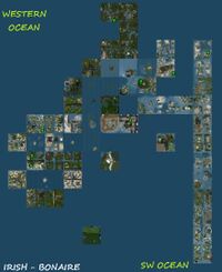
[[File:Irish-bonaire-2014.png|200px|thumb|right|Bonaire Sim Cluster in aug, 4th, 2014]] | [[File:Irish-bonaire-2014.png|200px|thumb|right|Bonaire Sim Cluster in aug, 4th, 2014]] | ||
Irish - Bonaire was a continent that existed on the grid until August 4th 2014, after an existence full of changes. | Irish - Bonaire was a continent that existed on the grid until August 4th 2014, after an existence full of changes. It became a [[Sim Cluster]] and earned the name ''Bonaire Sim cluster'' and designation number ''A231''. | ||
This continent is the result made of two estates (possible 3). It is an unofficial continent and its formation is the result of a random add of new sims. It is almost compleatly made of estate islands and navigable waters. | This continent is the result made of two estates (possible 3). It is an unofficial continent and its formation is the result of a random add of new sims. It is almost compleatly made of estate islands and navigable waters. | ||
Revision as of 12:05, 4 August 2014
Irish - Bonaire was a continent that existed on the grid until August 4th 2014, after an existence full of changes. It became a Sim Cluster and earned the name Bonaire Sim cluster and designation number A231.
This continent is the result made of two estates (possible 3). It is an unofficial continent and its formation is the result of a random add of new sims. It is almost compleatly made of estate islands and navigable waters.
History
In August 2013, the continent was made of 56 sims, with a total surface of 3067 square km. All sims were with direct water access, no sim completely submerged and no sim was complete dryland. Two, possible 3 estates existed at that time.
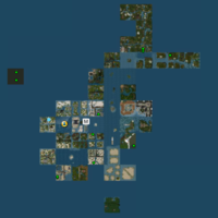
From August 1st to August 30th, a sim vanished from the map in the 'Irish' part. The Irish part of this continent vanished from the map, most probably at the end of September 2013. This leads to major changes in the form of the continent and also in the number of sims. If the number of sims drops below 30, Irish - Bonaire will become a Microcontinent. However, things are starting to change in late Octomber. New sims are created around the 'Bonaire' part of the continent, as you can see on the top-left map.
Also, the Artisan islands moved away from the continent.
In November 2013 the Irish islands moved close to Nautilus, where they are now known as the Seychelles Microcontinent, a part of the Nautilus continent. They form the Seychelles Subcontinent.
Things are changing again in 2014. This makes Irish-Bonaire the most dynamic of all continents. In January 26th 2014, Second Life Geography Team found that a new long and white Subcontinent was formed in South-East. The vast majority of these sims share the common name Isles. Previous map of Grid Sector G10 shows that the area hosted no sim in autumn 2013. This increased its number of sims up to 56, exactly its initial size in August 2013.
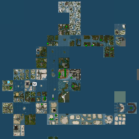
Unfortunately, in August 4th 2014, things changed again, but in worse. A lot of sims vanished from the grid and the continent split into smaller pieces. It became a Sim Cluster, with two inner Microcontinents. As a whole, there are still many sims, that could form back the continent if they will move to link one each other.
Geography
Altitude
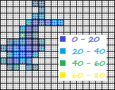
The Altitude map shows different elevation values then those found on other island continents, like Blake Sea, Eden or Caledon - Winterfel. The main difference is hte presence of high places (over 40 meters). They are mountains. Majority of mountains found on this continent are in fact separation lines between parcels. Other smaller mountains can be found too. They are high (sometimes over 100 meters) but never wide enough to cover a large part of a sim.
Divisions
The continent is composed of two different regions.
The Northern Region has a much darker texture and less surface covered with water. Ground is usually covered with temperate forests. Also, there is the highest mountain, about 170 meters, a sharp mountain range that divides a sim in two. Water is very deep. Also, the most Northern sims cover a large park along a river, with an alley and a lot of vegetation. Land can be purchased anywhere, including in the park.
The Southern Region looks more like a tropical beach, with a lot of islands and water for sailing. Almost all ground texture looks like sand. This is a beach paradise, with palm trees, where you can easy find a place to rezz boats.
Isles Region is new, in South-East. It is formed by 11 sims placed almost in a straight line. On map, they are whiter then other structures. They are made of smaller or larger islands and the vast majority of them are for sale.
Transportstion
There are a few small roads in North, along water.
Water transportation is the most logical way to traver around, since all sims have water access. In the center of this continent, there are flooded sims created for sailing.
Air transportation is possible.
Our survey detected two entity orbs, so Land With Restricted Access exists. This is not a major problem, since Protected Land exists and covers almost all the continental Water.
Estate status
It looks like now Bonaire estate is owning almost all the land in the area. Irish islands vanished and also the Artisan islands moved away. Still, smaller estates can be found in South.
Statistic data
Current size in sims: 70 (as a sim cluster)
Size in meters: 2.88 square km (2.82/2.56 km)
In past, as a continent, it had 56 sims, then reduced size and increased again to 44.
Coordinates
Coordinates are in sims, with longitude(min-max)/latitude(min-max) format. The sim coordinates can be downloaded from Gridsurvey [1] or an inworld detector.
Sim cluster: 717-742/1022-1041
Old coordinates were:
Continent: 726-736/1023-1037
Irish sims: 735-736/1023-1035
Artisan sims: 731-734/1032-1035
Bonaire sims: 730-732/1033-1037
South-West sims: 726-732/1027-1036
Grid Sector: G10
