Jeogeot Network
Return to main : Second Life Road Network Directory
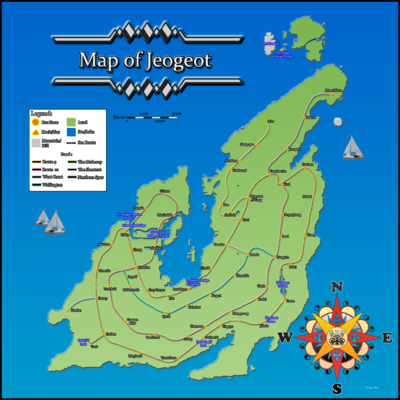
The Jeogeot continent contains two long interlocking routes: 9 and 10 with spurs and subsections, also the inland Wellington Road.
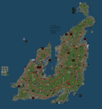
 click image for larger version
Route 9: The Great Way Round (Jeogeot Orbital)
This route links with Route 10 and makes a large circuit of the whole continent, requiring some challenging engineering features along the way.
Many interesting sights are to be found on this epic journey including ...
Route 9 Lordshore Bridge and Lookout Point
The picnic platform gives a stunning view of the new Lordshore suspension bridge spanning several sims.
Built with the latest materials, the bridge is over 400 meters long, with 40 meters of clearance below the main span.
Look around for surrounding wrecks and caves here !
Route 9 Deongseo Tunnel
A sub-aquatic road tunnel passing through the inland sea spanning four sims between Deongyeongju and Seoraksan.
Most of the tunnels length is tough plasti-glass construction, mostly leakproof.
This affords views of the plant life and underwater activities in this popular body of water.
Route 9 Han Loso Crater
A deep crater of unknown origin, possibly caused by a meteorite.
The road descends the crater wall steeply, crossing the dark waters by means of an old stone bridge.
Shapes and shadows lurk in the depths below, some of them moving ....
Take your scuba gear !
Route 9 Dun Ringill Park and Rez Zone
A Rez Zone on Route 9 adjoining a megalithic mound, to which it is linked by an attractive footbridge
There is also a butterfly and tropical house here of Victorian cast iron design, recently restored.
Route 9A: Jeogeot Northern Peninsula
A spur from Route 9 running into the northlands of Jeogeot
Route 9/9A intersection
Intersection of north road with Route 9 at Mogwa
Rez Zone here !
Route 9A terminus
Northern extremity of Route 9A
Rez Zone here !
Route 10 : Jeogeot Central Road
Route 9/10 Quenloo Crossroads
Intersection between Route 9 (North/South) and Route 10 (East-West)
Rez Zone here !
Route 10 Silvercreek Bridge
First of a new design of modern suspension bridge on mainland SL.
Constructed at the same time as its near-twin, the Pengallen Bridge in Zindra
Route 10 Silvercreek Tunnel
Near to the Silvercreek bridge, a new design of tunnel was also constructed to keep a watercourse clear.
Steep slopes but fun to drive through, or even skateboard !
Route 10 Ninereeds Bridge
A low level bridge crossing the river at Ninereeds
Lifting section in the centre for boat traffic.
"The Shortcut" : Linking Route 9, Route 10 and the Wellington Road
Dansim Junction
Route 9 access point
Rez Zone here !
Wellington Junction
Beginning of the Wellington Road from the Shortcut
Rez Zone here !
Nangrim Junction
Route 10 access point
Rez Zone here !
Wellington Road
Wellington Road begins in Chongno, travels through some lovely mainland areas, and ends in Hangflame Ridge.
The Great Hill
Come try your skateboarding skills!
- Rez zone: Noguri (5, 77, 99)
Contemplation Bridge
Relax and visit with friends.
Wellington Road Public Rez Zones
Lupoff
Molesworth
Quoll
Cairnlow
Chebi
Noguri
Technical data
The following numbers are distances, measured in km. Maximum estimated error is 5%.
Road 9 (anticlockwise measurement: sim + intersection):
Falcor (road 10 West):        0.00
Dewey (West coast road):      2.50
Exxilor (The moleway):        3.61
Baekga (Off-road):            6.75
Yeot (road 10 East):         15.38
Yangbaechu (North Spur):     16.03
Mogwa (road 9A):             17.03
Dansim (Shortcut):           18.54
Quenloo (road 10 North):     22.46
Falcor (road 10 West):       23.37
Road 10 (anticlockwise measurement, sim + intersection):
Falcor (road 9 West):         0.00
Quenloo (road 9 North):       4.63
Hangflame Ridge (Wellington): 5.03
Arang (off-road):             9.07
Nangrim (shortcut):          12.82
Yeot (road 9 East):          15.15
Shortcut (from West to East):
Dansim (road 9):              0.00
Boksik (Wellington):          0.71
Nangrim (road 10):            1.65
Wellington Road:
Hangflame Ridge (road 10):    0.00
Semoshi (Shortcut):           5.04
Other roads (total length):
Northern Spur Road:           3.35
Road 9A:                      4.44
West coast road:              0.96
The moleway:                  0.65
Off - road:                   0.34
Total measurements:
Isolated road pieces:         0
Road:                        54.61
Off-road:                     0.34
GRAND TOTAL:                 54.95
Jeogeot has a 54.95 km road network. It has two records: First, road 9 is the longest road on the grid. And second, it is the only Linden-owned continent without a fragmented road network. From any point, you can drive a car to any point of the roads, without having to pass over obstacles and missing road links.
External Links
Jeogeot - main page about the continent
Jeogeot Map http://jeogeot.protected-routes.com/
Return to main : Second Life Road Network Directory


