Difference between revisions of "Gaeta V Network"
| (12 intermediate revisions by the same user not shown) | |||
| Line 40: | Line 40: | ||
== Technical data == | == Technical data == | ||
[[File:Gaeta 5 road m.png|200px|thumb|right|Gaeta 5 road measurements]] | |||
The numbers listed below are distances in km. Maximum error is 5%. Gaeta 5 road network has an outer road ring (highly fragmented) and an inner ring (with only one gap). Measurements are done along the inner ring, starting in anticlockwise direction, from the gap. Unconnected road pieces are listed separately. | The numbers listed below are distances in km. Maximum error is 5%. Gaeta 5 road network has an outer road ring (highly fragmented) and an inner ring (with only one gap). Measurements are done along the inner ring, starting in anticlockwise direction, from the gap. Unconnected road pieces are listed separately. | ||
INNER RING | |||
Angkasawan (inner gap): 0.00 | Angkasawan (inner gap): 0.00 | ||
Road 7A North: 1.34 | Road 7A North: 1.34 | ||
Road 7A South: 4.36 | Road 7A South: 4.36 | ||
Road 7B South: 5.97 | Road 7B South: 5.97 | ||
Road 7B North: 8.16 | |||
Feokistow (inner gap): 9.74 | |||
CONNECTED PARTS FROM OUTER RING | |||
North-West: 0.20 | |||
South-West: 1.38 | |||
South-East: 0.96 | |||
North-East: 1.26 | |||
TOTAL CONNECTED ROADS: 13.54 | |||
Unconnected road sectors (parts of road 7): | |||
North West sector: 1.03 | |||
West Sector: 1.02 | |||
South West (beach road): 0.25 | |||
South East: 1.63 | |||
North East (tunnel): 0.44 | |||
Total data: | |||
*Total road network: 17.91 km | |||
*Classic road (asphalt, concrete, pavement): 17.91 | |||
*Unconnected roads: yes, 5 sectors | |||
*Sea access: yes, multiple docks. | |||
== See Also == | == See Also == | ||
Latest revision as of 14:18, 10 May 2014
Return to main : Second Life Road Network Directory
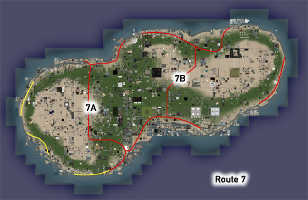
Gaeta is a small 'peanut' shaped continent to the east of Corsica and contains Route 7, a scenic road touring its coast, with two inland cross routes 7A and 7B completing the network.
Route 7 Libestus Pier, Libestus
Follow the road itself or put in a boat at the end of the pier and explore by sea!
Route 7 Squall Public Beach, Squall
Relax by the waves or head up the beach to explore Magellan Linden's campsite
Route 7 Helfell Infohub, Helfell
Mediterranean vistas abound around this new InfoHub
Route 7 Gaeta docks, (various)
These mark the transitions between improved roads and open water canals. Pick up a free LDPW boat here for easy sailing along the canals or other Linden seas.
Technical data
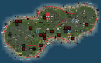
The numbers listed below are distances in km. Maximum error is 5%. Gaeta 5 road network has an outer road ring (highly fragmented) and an inner ring (with only one gap). Measurements are done along the inner ring, starting in anticlockwise direction, from the gap. Unconnected road pieces are listed separately.
INNER RING
Angkasawan (inner gap):     0.00
Road 7A North:              1.34
Road 7A South:              4.36
Road 7B South:              5.97
Road 7B North:              8.16
Feokistow (inner gap):      9.74
CONNECTED PARTS FROM OUTER RING
North-West:                 0.20
South-West:                 1.38
South-East:                 0.96
North-East:                 1.26
TOTAL CONNECTED ROADS:     13.54
Unconnected road sectors (parts of road 7):
North West sector:          1.03
West Sector:                1.02
South West (beach road):    0.25
South East:                 1.63
North East (tunnel):        0.44
Total data:
- Total road network: 17.91 km
- Classic road (asphalt, concrete, pavement): 17.91
- Unconnected roads: yes, 5 sectors
- Sea access: yes, multiple docks.
See Also
Gaeta 5 - main article about the continent
Return to main : Second Life Road Network Directory


