Difference between revisions of "Europe Continent"
| Line 26: | Line 26: | ||
This continent is composed of a high number of islands, separated by rivers or channels. Waterways are not large to form inland seas, but they still are navigable. Islands are smaller or larger, they fit inside a single sim or cover multiple sims. Average altitude is higher then 20 meters and more then half of the land is above sea level. | This continent is composed of a high number of islands, separated by rivers or channels. Waterways are not large to form inland seas, but they still are navigable. Islands are smaller or larger, they fit inside a single sim or cover multiple sims. Average altitude is higher then 20 meters and more then half of the land is above sea level. | ||
The highest | The highest [[Altitude]] (66 meters) is in Porto Di Crotone sim, on the top of a mountain. There are a few higher hills and some low mountains allover the continent. Flat plateaus are also present. | ||
== Coordinates == | == Coordinates == | ||
The following | The following [[Coordinates]] are in sims, with the format: longitude(min-max)/latitude(min-max). Coordinates can be obtained for every sim from Gridsurvey [http://www.gridsurvey.com]. | ||
Continent: 898-903/1306-1312 | Continent: 898-903/1306-1312 | ||
Revision as of 11:02, 24 November 2013
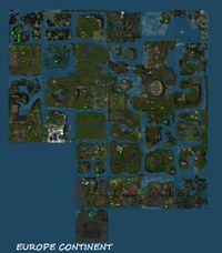
Europe Continent (or Europe Sea) is a private continent, created with the particular style of European middle-ages. The geographic features vary from place to place. There are many navigable channels and internal seas. Buildings are middle-age themed and usually the residents wear middle-age costumes. The name is not official.
The official name is Buona Pesca Archipelago. The owners didn't see it as a continent (even if it has more then 30 sims, so it is a continent).
Statistic Data
Size in sims: 33 (7/6)
Size in meters:2.16 square km (1.79/1.54 km)
Sea sims (flooded with water): 0
Coast sims (with water access): 33
Land sims (no water): 0
Sims with road access: 0
Population density: high.
Geography
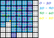
This continent is composed of a high number of islands, separated by rivers or channels. Waterways are not large to form inland seas, but they still are navigable. Islands are smaller or larger, they fit inside a single sim or cover multiple sims. Average altitude is higher then 20 meters and more then half of the land is above sea level.
The highest Altitude (66 meters) is in Porto Di Crotone sim, on the top of a mountain. There are a few higher hills and some low mountains allover the continent. Flat plateaus are also present.
Coordinates
The following Coordinates are in sims, with the format: longitude(min-max)/latitude(min-max). Coordinates can be obtained for every sim from Gridsurvey [1].
Continent: 898-903/1306-1312
Grid Sector: H13, I13
See also
[2] - a few words
[3] - About Buona Pesca Archipelago
[4] - Rules
[5] - Pictures

