Difference between revisions of "Satori"
| Line 18: | Line 18: | ||
Sims with no direct access: 236 | Sims with no direct access: 236 | ||
== Coordinates == | |||
The coordinares here are given in sims, following the same model used by Gridsurvey [http://www.gridsurvey.com] for the position of every sim. The numbers are: longitude (min - max) / latitude (min - max). There is no official geographic guide for Satory. There is a lack of geographical names. So, the coordinates are given here for diverse areas of the continent. Some sims have Slavic names (including Russian) and form the Slavic Region (note that they are only 30% of the sim names). Also, the border with [[Nautilus]] is not clear. | |||
Continent:1100-1131/1005-1047 | |||
Slavic Region: 1113-1120/1030-1047 | |||
East Peninsula: 1121-1136/1031-1046 | |||
North-West Peninsula: 1101-1112/1039-1047 | |||
Central Landmass: 1100-1112/1030-1038 | |||
South Landmass: 1100-1120/1116-1130 | |||
South Peninsula: 1101-1108/1005-1115 | |||
== Links == | == Links == | ||
Revision as of 05:30, 6 September 2013
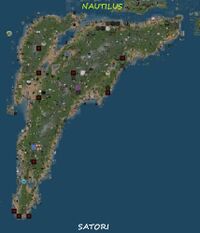
Satori is a mainland continent. It was first created as a Japanese continent. Today, the population of this continent is worldwide and the most spoken language is English. This continent has many sims woth Slavic-related names (many are Russian names). Their transcription in Lathin alphabet can be very confusing for a person who is used with Cyrillic alphabet. Satori is linked to the North with Nautilus and to the North-East with Blake Sea. The continent is made of a large mass of dryland. The road network is less developed and there are large places of abandoned land. Togeyher with Nautilus, Satori forms a megacontinent, like Euroasia in real world.
Statistics
Size in sims: 709 (N-S 43, E-W 36)
Size in meters: 46.47 square km (11.01/9.22 km)
Sea sims (complete flooded): 26
Coast sims (water access): 205
Land sim (no water): 478
Sims with road access: 162
Sims with no direct access: 236
Coordinates
The coordinares here are given in sims, following the same model used by Gridsurvey [1] for the position of every sim. The numbers are: longitude (min - max) / latitude (min - max). There is no official geographic guide for Satory. There is a lack of geographical names. So, the coordinates are given here for diverse areas of the continent. Some sims have Slavic names (including Russian) and form the Slavic Region (note that they are only 30% of the sim names). Also, the border with Nautilus is not clear.
Continent:1100-1131/1005-1047
Slavic Region: 1113-1120/1030-1047
East Peninsula: 1121-1136/1031-1046
North-West Peninsula: 1101-1112/1039-1047
Central Landmass: 1100-1112/1030-1038
South Landmass: 1100-1120/1116-1130
South Peninsula: 1101-1108/1005-1115
Links
Satori Network the roads of Satori
[2] - list of airports
[3] - geographic features
