Difference between revisions of "Nautilus"
| Line 1: | Line 1: | ||
[[File:Nautilus 2013.png|200px|thumb|right|Nautilus continent in aug 2013]] | [[File:Nautilus 2013.png|200px|thumb|right|Nautilus continent in aug 2013]] | ||
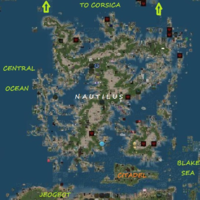
Nautilus is the second recommended destination for sailing, after [[Blake | Nautilus is the second recommended destination for sailing, after [[Blake Sea]]. This continent is linked to [[Corsica]] at North, with [[Satori]] at South and with [[Blake Sea]] at South-East. Together with Satori, it forms a supercontinent, like Euroasia in real workd. | ||
In South-East, close to the connection with Blake Sea, there is Nautilus City, a city on an island, with an inner citadel, a complex road network and a navigable channel. | In South-East, close to the connection with Blake Sea, there is Nautilus City, a city on an island, with an inner citadel, a complex road network and a navigable channel. | ||
Revision as of 22:18, 5 September 2013
Nautilus is the second recommended destination for sailing, after Blake Sea. This continent is linked to Corsica at North, with Satori at South and with Blake Sea at South-East. Together with Satori, it forms a supercontinent, like Euroasia in real workd.
In South-East, close to the connection with Blake Sea, there is Nautilus City, a city on an island, with an inner citadel, a complex road network and a navigable channel.
The continent has a complex coast line, with many gulfs and peninsulas. The road system is not well developed, with many missing parts. The coast is usually populated, while the mainland sims inside the continent, without access to road and water, are usually abandoned. The seas are usually not deep and the dryland is a plain.
Statistics
Note: It's difficult to make a clear separation between Nautilus and Satori.
Size in sims: 842 (N-S 34, E-W 32)
Size in meters: 55.18 square km (8.70/8.19 km)
Sea sims (only with water): 172
Coast sims (direct access to water): 534
Land sims (no water): 136
Sims with road access: 112
Sims without direct access: 77
Population density: med-low
Note: Population density is higher in coast sims and very low in land sims.
Coordinates
The following coordinates are given in sims, with the same principles used by Gridsurvey [1]. The separation between Nautilus and Satori is not clear. Subdivisions of Nautilus Continent are not shown on any map and on no site. So, the subdivisions marked here are deduced directly from map shape. The only clear subcontinent is Nautilus City. The separation line between Nautilus and Blake Sea is more clear. The numbers below are: longitude (min - max) / latitude (min - max).
Continent: 1106-1137/1047-1081
Nautilus City: 1120-1131/1047-1051
Blake Sea Crossing Area: 1123-1034/1147-1053
Satori Sea Crossing Area: 1111-1119/1047-1051
South-East Island: 1125-1131/1052-1060
South Sea: 1120-1124/1052-1060
West Sea: 1106-1119/1057-1070
Star-like Gulf: 1122-1131/1066-1072
North-West Peninsula: 1107-1119/1071-1081
Northern Shores: 1120-1137/1067/1075
East Sea (North Basin): 1132-1136/1066/1072
East Sea (Central Basin): 1126-1134/1061-1065
East Sea (South Basin): 1132-1134/1054-1060
Central Landmass: 1120-1125/1061-1072
South Peninsula: 1109-1119/1052-1056
Links
[2] - Nautilus Ferry Service
Nautilus Network - road network
[3] - Second Life Wikia
