Difference between revisions of "Gaeta 1"
| (7 intermediate revisions by 2 users not shown) | |||
| Line 6: | Line 6: | ||
== History == | == History == | ||
The West and South parts of Gaeta 1 were built in a single day, | The West and South parts of Gaeta 1 were built in a single day, June 4th, 2008. The North branch was built later. The South-East part is still unfinished. | ||
== Coordinates == | == Coordinates == | ||
The | The [[Coordinates]] are in sims, as shown by Gridsurvey [http://www.gridsurvey.com].First numbers are longitude (min and max), last numbers are latitude (min and max). | ||
Coordinates:1140-1155/1126 | Coordinates:1140-1155/1126-1130 | ||
1140-1149/1126-1130 West Gaeta | 1140-1149/1126-1130 West Gaeta | ||
| Line 41: | Line 41: | ||
== Geography == | == Geography == | ||
Gaeta 1 is one of the smallest Linden-owned continent, smaller then some private continents like [[Eden]] or [[Estate Continent]]. | |||
=== Overall === | |||
Gaeta 1 is the most unpopulated continent. Even so, the amount of abandoned land is not big. The main reason for this is that a big surface of land was never sold and is still Linden land. Even if the road system is too small, the unsold parcels allow access almost to the entire continent. | Gaeta 1 is the most unpopulated continent. Even so, the amount of abandoned land is not big. The main reason for this is that a big surface of land was never sold and is still Linden land. Even if the road system is too small, the unsold parcels allow access almost to the entire continent. | ||
Land is divided in 4 major groups: protected land (usually water sims), Linden land (parcels that have never been sold), rental land (belongs to important rentals) and resident parcels (used or abandoned land). | Land is divided in 4 major groups: protected land (usually water sims), Linden land (parcels that have never been sold), rental land (belongs to important rentals, many times it appears as [[Unused Land]]) and resident parcels (used or abandoned land). Recently (late autumn 2013), Linden land has become [[Abandoned Land]]. | ||
Gaeta 1 is a large plain. It is the most flat continent. The North part is a perfect plain. In North-West peninsula, the most populated part, there is a smooth hill. The plain in South is more elevated, but still a plain. There are no depressions. High borders and obstacles created by terraforming can be seen from place to place, on abandoned land parcels. Sometimes, small slopes can be created from terraforming. | |||
Almost all oceanic [[Water]] is [[Protected Land]] and is navigable. Ocean shores have a large beach of yellow sand and also the ocean floor is yellow. Sometimes, groups of stones can be seen under water. Unlike other places, ocean floor has no slopes or holes. | |||
=== Altitude === | |||
[[File:Gaeta 1 altitude.png|200px|thumb|right|Altitude map]] | |||
[[Altitude]] map of Gaeta 1 reveals the real shape of the continent. All the North part is smooth, with low altitudes, lower then any other continent. Only in the North-West peninsula, there is a small hill. Its presence was revealed by unexpected altitude. In South, there is a gradual transition from the smooth shores to higher plains. There is a clear evidence for an oceanic plain, continued with a higher continental plain. This feature is also seen on [[Gaeta 5]]. Altitude map confirmed that there are no mountains, no massive altitude transitions and no holes or depressions. | |||
The most elevated point is 100 meters high, in Lemontal sim. | The most elevated point is 100 meters high, in Lemontal sim. | ||
| Line 56: | Line 63: | ||
== Transportation == | == Transportation == | ||
Gaeta 1 has only two very short beach roads. However, automatic transportation exists thanks to a small pod vehicle that travels across some unsold parcels. The continent has many | Gaeta 1 has only two very short beach roads. However, automatic transportation exists thanks to a small pod vehicle that travels across some unsold parcels. The continent has many [[Water]] sims and some ports, but navigation is less developed because there is no connection to another continent. Air transportation is also limited to the fact that an airplane cannot leave the continent and there is no airport. | ||
The low population density is also an advantage. Gaeta 1 is a good place for free horse riding or for a land rover to explore. This is very easy in East. The oceanic waters in North-West are some of the most quiet seas on the grid, a good place for lonely sailing. | |||
=== Transportation efficiency === | |||
[[File:gaeta1water.png|200px|thumb|right|Gaeta 1 Waterways]] | |||
More info at [[Gaeta I Network]] and [[Waterways]]. | |||
Total road network: 4.58 | |||
Paths: 2.17 | |||
Off-road: 2.41 | |||
Sea connection: yes | |||
Unconnected road pieces: 3 | |||
Continent surface: 9.24 | |||
Land coverage: 0.261 km per square km | |||
[[Second Life Road Network Directory#Road efficiency|Road efficiency index]]: 0.202 | |||
[[Waterways#Water Efficiency Index|Water efficiency index]]: 1.695 | |||
Overall efficiency index: 1.897 | |||
=== Accessibility === | |||
[[Land With Restricted Access]] is present in Gaeta 1. Our survey found an entity orb teleporter and a few ban lines. Since population density is very low, these obstacles are not a big threat for travelers and explorers. | |||
== More information == | == More information == | ||
Latest revision as of 16:13, 4 January 2023
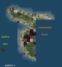
Gaeta 1 is an unfinished mainland continent.
Gaeta 1 is the continent with the largest surface of abandoned land and directly-owned Linden land. It is not connected to other continents and its South-East part is unfinished. This small continent has no airport and only two small beach roads (in fact two paths). In East, there are sims of Linden Land, land that have never been sold.
History
The West and South parts of Gaeta 1 were built in a single day, June 4th, 2008. The North branch was built later. The South-East part is still unfinished.
Coordinates
The Coordinates are in sims, as shown by Gridsurvey [1].First numbers are longitude (min and max), last numbers are latitude (min and max).
Coordinates:1140-1155/1126-1130
1140-1149/1126-1130 West Gaeta
1144-1149/1112-1125 South Gaeta
1150-1155/1126-1128 North Gaeta
Grid Sector:K11
Statistics
Size in sims: 141 (19/16)
Size in km: 9.24 (4.86/4.10)
Sims compleatly flooded with water: 38
Coast sims (direct access to water): 54
Sims without water: 49
Sims with road access: 12
Sims without direct access: 39
Population density: very low
Geography
Gaeta 1 is one of the smallest Linden-owned continent, smaller then some private continents like Eden or Estate Continent.
Overall
Gaeta 1 is the most unpopulated continent. Even so, the amount of abandoned land is not big. The main reason for this is that a big surface of land was never sold and is still Linden land. Even if the road system is too small, the unsold parcels allow access almost to the entire continent.
Land is divided in 4 major groups: protected land (usually water sims), Linden land (parcels that have never been sold), rental land (belongs to important rentals, many times it appears as Unused Land) and resident parcels (used or abandoned land). Recently (late autumn 2013), Linden land has become Abandoned Land.
Gaeta 1 is a large plain. It is the most flat continent. The North part is a perfect plain. In North-West peninsula, the most populated part, there is a smooth hill. The plain in South is more elevated, but still a plain. There are no depressions. High borders and obstacles created by terraforming can be seen from place to place, on abandoned land parcels. Sometimes, small slopes can be created from terraforming.
Almost all oceanic Water is Protected Land and is navigable. Ocean shores have a large beach of yellow sand and also the ocean floor is yellow. Sometimes, groups of stones can be seen under water. Unlike other places, ocean floor has no slopes or holes.
Altitude
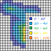
Altitude map of Gaeta 1 reveals the real shape of the continent. All the North part is smooth, with low altitudes, lower then any other continent. Only in the North-West peninsula, there is a small hill. Its presence was revealed by unexpected altitude. In South, there is a gradual transition from the smooth shores to higher plains. There is a clear evidence for an oceanic plain, continued with a higher continental plain. This feature is also seen on Gaeta 5. Altitude map confirmed that there are no mountains, no massive altitude transitions and no holes or depressions.
The most elevated point is 100 meters high, in Lemontal sim.
Transportation
Gaeta 1 has only two very short beach roads. However, automatic transportation exists thanks to a small pod vehicle that travels across some unsold parcels. The continent has many Water sims and some ports, but navigation is less developed because there is no connection to another continent. Air transportation is also limited to the fact that an airplane cannot leave the continent and there is no airport.
The low population density is also an advantage. Gaeta 1 is a good place for free horse riding or for a land rover to explore. This is very easy in East. The oceanic waters in North-West are some of the most quiet seas on the grid, a good place for lonely sailing.
Transportation efficiency
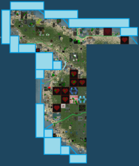
More info at Gaeta I Network and Waterways.
Total road network:       4.58
Paths:                    2.17
Off-road:                 2.41
Sea connection:            yes
Unconnected road pieces:     3
Continent surface:        9.24
Land coverage:           0.261 km per square km
Road efficiency index: 0.202
Water efficiency index: 1.695
Overall efficiency index: 1.897
Accessibility
Land With Restricted Access is present in Gaeta 1. Our survey found an entity orb teleporter and a few ban lines. Since population density is very low, these obstacles are not a big threat for travelers and explorers.
More information
Second Life Road Network Directory - for the road network
[2] - an older map
[3] - from the old days when Gaeta was in construction


