Difference between revisions of "Gaeta 5"
| Line 58: | Line 58: | ||
== Transportation and accesibility == | == Transportation and accesibility == | ||
Gaeta 5 has a low-developed road network, but with continental cover. Ground transportation is also possible by using parcels of [[ | Gaeta 5 has a low-developed road network, but with continental cover. Ground transportation is also possible by using parcels of [[Abandoned Land]]. It is possible to travel along entire continent, by foot, by horse or by motorbike. | ||
Water transportation is important. Coastal waterway is navigable and surrounds the entire continent. More even, there are navigable channels close to the shores, that extend the road network and offer incredible landscapes. | Water transportation is important. Coastal waterway is navigable and surrounds the entire continent. More even, there are navigable channels close to the shores, that extend the road network and offer incredible landscapes. | ||
Revision as of 12:18, 20 November 2013
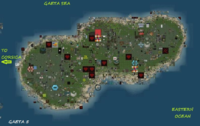
Gaeta 5 is the only finished continent of the Gaeta series. The initial project was to build 5 continents (named from Gaeta 1 to Gaeta 5), then to unite them into a single block of sims. Today, only Gaeta 5 is complete and a part of Gaeta 1 was built. Gaeta 5 is the most compact continent, with no gulfs or estuaries. On map, has a pea-shape or a potato-shape. This continent is an endless plain. It is linked to Corsica by a two-sim large passage (see Transcontinental Channels).
History
Gaeta 5 was built soon after Corsica. Construction started in april 14th 2008 and ended in may 25th 2008. It took only 41 days to build the continent [1].
Statistics
Size in sims: 385 (N-S 19, E-W 32)
Size in meters: 25.23 square km (4.86/8.19 km)
Sea sims (complete flooded): 81
Coast sims (direct water access): 91
Dryland sims (no water access): 213
Sims with road access: 81 (sometimes they are continued with navigable channels).
Sims without direct access: 138
Population density: low
Coordinates
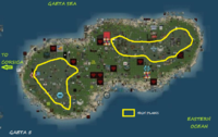
The following numbers are sim coordinates, as they are available from Gridsurvey [2] in the following format: longitude(min) - longitude(max) / latitude(min) - latitude(max). Gaeta 5 has no subcontinents, however it can be devided into two smaller subcontinents.
Continent: 1158-1189/1081-1099
West Gaeta: 1158-1174/1081-1098
East Gaeta: 1175-1189/1085-1099
Grid Sector:K10
Geography
Gaeta 5 is similar with Gaeta 1. Both continents are a gigantic plain. However, Gaeta 5 has an average low plain and two higher plains. Also, the ocean floor has its own features.
The low plain starts from the seaside, with a large sand beach. This plain changes texture with every meter in altitude. It is easy to terraform. A large part of this plain is abandoned land, with slopes and holes. Always, Gaeta 5 has low plains around the shores. The center of the continent is a large depression, a low plain. They are never higher then 60 meters.
The high plain looks like a hill, but if we compare the altitude and declivity to other continents, it is a plain. The average altitude is about 62 meters high (or 44 meters above sea level). There is a small difference in color between the lower and the higher plains. Unfortunately, these plains are full of abandoned land. Maximum altitude was found to be 168 meters. Vrey high places look like hills.
The ocean floor is similar to the ocean floor in Gaeta 1. Close to the coast, water is not deep and terraforming is very easy.
Altitude
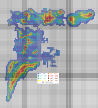
Altitude map of Gaeta 5 is corelated with the Geographical features of the continent. The seaside is very smooth, without a coast with high declivity. There are no cliffs or mountains to form shores with high declivity. Near the shores, the oceanic plain has low altitudes and covers about half of the entire continent.
The center of the continent is a large depression, with a maximum elevage of 45 meters. There is a road following the West end of the central depression. Land is so low, that ground oceanic texture extends an entire sim to continental center. However, all plains of Gaeta 5 are not complete flat.
The high plains, separated by the central depression, show an interesting and unique feature. Altitude rises from center to extremity. The altitude rises so slow, that while traveling from center to East or West, you will not notice it. Everything looks like a large plain with small slopes. But even so, the highest altitude is 168 meters, higher then many other continents, more then Corsica, Nautilus or Satori.
Transportation and accesibility
Gaeta 5 has a low-developed road network, but with continental cover. Ground transportation is also possible by using parcels of Abandoned Land. It is possible to travel along entire continent, by foot, by horse or by motorbike.
Water transportation is important. Coastal waterway is navigable and surrounds the entire continent. More even, there are navigable channels close to the shores, that extend the road network and offer incredible landscapes.
Air transportation is possible by flying or by airplanes. There are a few airports.
Accesibility
Gaeta 5 is less populated then nearby Corsica and has many parcels of Abandoned Land or Unused Land. There are ban lines and entity orb teleporters, but their frequence is low, somehow similar to Sansara. Percent of Land With Restricted Access of all Inhabited Land is, however, similar to the values found on Corsica.
Other links
Gaeta V Network - roads in Gaeta
[3] - Second Life Wikia about Gaeta
[4] - the Gaeta airports
[5] - a road trip through Gaeta 5.


