Mountains Of East Continents
The East Linden-owned continents, except for Sharp Continent, share some common features. Unlike the central and old continents, their Geography consists mainly of plains and plateaus. Basically, the term defines all mountains found on other Linden-owned continent except for Heterocera, Sansara and Jeogeot. Sharp Continent has its own article about its mountains (see below the lists of mountain articles), so it will also be excluded from list.
As much as possible, this article is created using the style of a touristic guide.
Generations
Based on the age they were created, all mainalnd continents can be grouped in 3 generations. More then this, each generation has some common Geographic features.
Generation 1 includes the so-called Old World: Sansara, Sharp Continent and Heterocera. Jeogeot is a transitional continent between generations 1 and 2. These continents have some common features: very high mountains (over 300 meters), high diversity of Geographic features, a big amount of Protected Land, highly developed transportation networks and a higher population density.
Generation 2 includes the so-called New World: Corsica, Nautilus, Satori, Gaeta 1 and Gaeta 5. These continents have a less spectacular Geography, with large plains and plateaus, lower fragmentation, smaller mountains (below 200 meters) and smaller declivity. Mountains are rare. These continents have more Abandoned Land and their population density is a lot lower. Transportation network is low developed and sometimes does not cover the whole continent. The comparation is also because Satori looks like South america and the new continents are separated by Central Ocean exactly how Atlantic Ocean separates in real world America from the old world.
Generation 3 includes the last continents built: Zindra and the four Premium Continents. These structures are smaller and created by a complete different concept: Much of the land is perfect flat, ground texture is different and altitudes much lower. Premium continents are a result of Geographic clonation, while Zindra is much more complex even then second generation continents.
The New World
Basically, only Nautilus and Satori have mountains. Even so, a paragraph can be said about the other continents:
Corsica
Corsica probably has no mountain, but large, endless plateaus surrounded by plains. The highest point was detected in Android sim, 163 meters. Seen from coast, it looks like a mountain, even if it is in fact the border of a plateau. It is close to the shore, so a good way to explore it is to start from nearby Laserlight sim, on the circuit road, at 65 meters high. Climbing is not an easy task because there are many walls created by terraforming and a lot of Land With Restricted Access. Up, there is a flat plateau with high altitudes and not very populated. Ground texture is that of rocky, dried land.
From here, we can walk almost any direction. Population density is low on the plateau.
Another place in Corsica, that really looks like a mountain, is in South, around Temple Of The Prim. There is a path (not a road) that stretches through a few sims: Sardo, Vaktarin, Sheerstone and Kwaito. The largest part of this road is in fact a long wooden bridge, large enough for a person or a motorbike, but not for a car. In Kwaito, it climbs on top of the plateau, to Temple Of The Prim (an unfinished building). The land around this road is not too populated, landscape is great and it looks like you are in a mountain region. The only vehicle you will see is one of the Yava Script Pods every 30 minutes. This place is so quiet and unknown by many people, that it is a perfect destination if you want to be alone and relax. However, once you climb to the top, you see that this is not a mountain, but a high plateau like the many similar plateaus found in Corsica.
A tiny peak (57 meters high) exists in Eldfell sim.
Gaeta 1
This small and unfinished continent has the reputation of being the most unpopulated continent. Entire sims are made of abandoned land and there is even land that has never been sold. This continent is made of a large, endless plain. Even so, it still has a notable maximum altitude of 100 meters in Lemontal sim. Unfortunately, the highest parcel of the continent has access restrictions.
Gaeta 1 is a good place for sailing. Its waters are less populated and this makes it very quiet. Unknown for many residents is that this little continent is one of the best place for horse riding and off-road driving. A bit more difficult is to find a rezz zone, but once you found it, driving is not a problem. This continent has only two small beach roads. You can rezz a vehicle anywhere on them and then you can start exploring.
Gaeta 5
Gaeta 5 is similar to Gaeta 1, only that it is complete and more populated. This continent is formed of low plains ahd high plains. It has a large central depression. Even so, this plain continent has the record of being higher then all other continents listed here.
Suppose we make a West-East trip through Gaeta 1. We will start at a road, close to the shores. Near roads, there are many buildings and it might be difficult to get through them. Then, construction density decreases. Next, we see a hill, in fact it is the separation between low plains and high plains. A maximum altitude can be reached in Ischel, 150 meters. In its nearby sim, Poidor, the highest point is 168 meters high, inside a large wooden building with restricted access. While we continue our trip, altitude decreases slowly, so slow that we don't even notice. This is a plain full of terraforming remnants, a lot of walls very difficult to get accross. Flying might be the only access way, even if we are in a low plain. Then, a lot of inhabited parcels can be seen. There is a road in front of us, but it becomes difficult to reach it. Gaeta 5 has a very low network density. And to make things even worse, many parcels around the roads have access restrictions. They use ban lines, entity orbs and very often they are encircled by walls or large prims. Except for an endless terraformed plain, there is almost nothing to see here. Finally, we will reach another road and then the East end of this continent.
Nautilus
Nautiuls is a continent of the sea, but it still has mountains. They are something between a mountain and a plateau, with lower declivity but without much flat land on their top. It is better to call them hills. They don't form a continous mountain range.
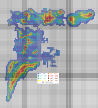
Exploring them is a difficult task. Every tourist must beware that Nautilus is the place with highest density of entity orbs and ban lines. It is basically impossible to walk from Satori to Corsica, you will be teleported away for sure. Nautilus has one of the most unefficient road systems, separated in North and South, without offering a continental network. Places near the coast are much more populated, but they block access to higher places. This might be the reason why all highland of Nautilus is abandoned. To have an idea how unfriendly this area is, think that the drone that made altitude map for Nautilus was ejected 50 times. The second unfriendly continent is Corsica, where the same drone was ejected 20 times. In Heterocera, this hapened only twice.
Tourist Route
One tourist route is possible (at least in theory) from North to South, from Camorro road end to Plenodyes road end. We start from camorro, walking through a plateau, then the mountains are visible in front of us. We start climbing, avoiding any buildings. After 500 meters, we reach 154 meters in Caso Milo. From here, we continue to the next mountain we see in front of us, Maggiore 141 meters). Another peak is visible to our left, but we go forward. There are a few bioldings ahead that need to be avoided. After this, we walk along a very smooth mountain range. Altitude is 110 meters.
In Padan sim, a long wall blocks our way through. Don't try to go right or jump over it. The only safe way is left, through Criptomono sim, even if it is a very long way. Our trip ends in Nimnan, there is no way to go through. All inhabited parcels around us have restricted access. The only way through is to go right and avoid all obstacles. It is a long loop, but the only possible way to continue. Soon, we enter Secret Kiss sim. Here, land is owned by two corporations that allow us to go through.
Altitude drops to 73 meters and the ground is covered with grass. If you ride a horse, it will be happy here. The hills are more smooth in here. Then, we start to climb again, slowly. It is not a difficile path. We climb to 100 meters, then to 130. The next parcels we see in front of us are not friendly. It is better to avoid the top of this hill by going to right. Almost every parcel that is not abandoned land doesn.t allow us to walk through. The most strange thing is that this is Unused Land, there is almost nothing on them.
Finally, in Misto Presto, we reach a complete flat plateau, 154 meters high. From here, at some point, we go right and down. The South road end is nearby, in Pleonydes sim, at 81 meters high.
Satori
Satori is the only continent in the new world that has mountains. These mountains are small and found in a single place. All other 'mountains' are in fact plateau borders that sepparates the higher plains (plateaus) from the lower ones.
Highest altitude is in Ennin sim, where you can find plateaus with 128 meters high (recently, by terraforming, someone increased its land altitude to 131 meters). To get there, it is easy. There are many roads around and walking on abandoned land is not difficult.
Mountains of Satori are small and form a little mountain range. They stretch through Carrion, Lycanthrope and Mabinogion sim. They are a separation line between a low plain (to West) and a depression (to East), both partially flooded. This might be the only touristic mountain route in the new world:
Tourist Route
We start our journey in Totem sim, on the road. From here, at a very careful look, we might see to East some small mountains. We leave the road and start walking. We climb a bit on the plain, to an altitude of 63 meters (the road was at 55). The mountains are now clearly visible and the end of a lake can be seen to left. We go down to reach the water. At this point, we start climbing. It is not important what route we follow (actually, there is no path). Soon, we reach the top. To North (left), we can see how the mountains are smaller and soon end in water. To South, (right) it looks like they are even higher and this is the way we will go. We follow the mountains South. In Carrion, maximum altitude is 84 meters. To left, we see a lake and a rural area. To right, the plain is flat to the horison. We enter Lycanthrope sim, where altitude is 79 meters and there is a sharp plateau on top of the mountain. Then, altitude decreases to 67 and a building is on our right. We start climbing again, to 83 meters, near a forest. We find a second plateau (77 meters), then climb to another peak (85 meters, highest point on this mountain range). Soon after this, we enter Mabinogion sim. A large lake is visible to our right, whil on left, we see a dry depression and the high plains of Satori far away. Altitude drops to 55 meters, then we climb one low peak, mount Loogaroo (71 meters). This is a nice place to relax, with Roman columns and an aquarium. Finally, in Lobishomen sim, the mountains end in an amusament park. Behind it, they are unrecognisable in the surrounding plain. Here, we should go left (East), trying to reach the road in Camazotz sim. For this, we have to go through the hills that separate low plains from high plains. These hills are very affected by terraforming.
Third Generation
These continents replaced slope plateaus with perfect flat ones. They have an alternance of terraces.
Premium continents
All 4 premium continents have similar features. Premium East is the most complete. It has two sims with mountains, forming a Japanese garden. The same garden can be found in Premium South 2 and Premium South 3 and in exactly the same place, South-West. These mountains are 156 meters high, in contrast with 63, the highest point on the plateaus. The mountains are made for decorative reasons, not for climbing, but climbing them is not forbidden. This park is the most interesting place on premium continents. It really worths a visit.
Zindra
Zindra is not made as a place for touristic adventures, even if its Geographic features are interesting. However, tourism here can be token to another level. You can try climbing Zindra mountains completely naked without problems. This is also true for sea lovers, Zindra is the best place for naked sailing.
So, take an adequate mountain costumation, take your partner and your friends and start on one of the touristic routes suggested here.
Unlike other Linden-owned continents, Zindra has no automated transportation on its roads. This includes the well known Yava Script Pod vehicles. The reason for this is that land does not allow these vehicles to travel, even if it is Protected Land. Also, these roads have a lack of rezz zones, so road transportation is sometimes highly difficult.
Geography
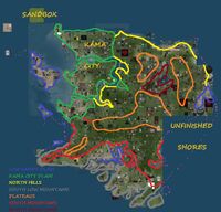
North Mountains have the official name Tyrell Mountains. They are usually round-shaped, with smooth peaks and a different texture then all land around them. There are a few similar mountains in Sansara or Jeogeot.
South Mountains are borders of the large plateau system in center of the continent. they are very high in South and look a bit similar with the Element Sims in South Sansara. The main difference is that the South mountains of Sansara have smooth plateaus on their top, while the mountains of South Zindra have flat plateaus.
South Low Mountains (or South Low Hills) are placed in South, near waterways. They have a significant declivity and their top is usually smooth. Terraforming affected many land surfaces, so it is difficult to travel accross. Roads are also rare in this part of the continent. Unlike the hills in North, the low mountains are much more complex and interesting.
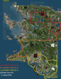
Tourist Route 1
This is the way to visit the Tyrell Mountains. We can start our journey in Kama City and go by road to the mountains. From Kama Center, we go directly South. Beware that boad center is almost always the sim border and nearly all intersections are in fact at a sim corner (so they are hosted by 4 sims). All road crossings might cause sim crossing problems. We pass over the river in Oritz. A dam is visible to right (one of the 3 Dams in Zindra). Then, at the intersection where this road ends, we turn left. We left the flat plain of inner Kama to a more rough plain in South Kama.
Soon, we drive again over the river and leave the city. If we walk a bit to left, we can find another dam here. The difference is immediately noted. Roads are not illuminated by Kama modern light system and are no longer at sim borders. We enter Laffoon sim. Here, we start climbing to reach the top of a plateau. Soon we finish climbing, at 80 meters high. Then, we go a bit lower, to 64 meters. We enter the flat plateaus of Zindra. They are more flattern then almost any other place on the grid. They look similar to Premium Continents (in fact, they are the same generation).
We arrive Novazeit sim and the first mountains are visible. Hree, we have a few variations from our path. The main way is to drive forward on the road. Variation 1 is to explore the mountains South (left) of the road, variation 2 is right (North) of the road.
If we don't follow the variations, we drive on the road between the mountains until we see a river to left. It is time to leave the road. We can drive a bit even through this terrain. The mountains must be left to us. Driving is possible until we reach the end of Juliana sim. We enter Dunstone, a place with much water and vegetation. From here, driving is no longer possible. We can continue by foot by following the mountains (and not climbing them). They must be on our left. Then, some ban lines will force us to go right. We continue forward through Lesser Farnley sim. If we continue forward, we will reach a road.
We can drive on this road and take the first turn left. We will arrive in Dratzo sim, the point to start a new adventure, on variation 3. If not, we can drive this road forward. We soon notice that altitude grows left and right to us, even if the road doesn't climb. After 150 meters, we see a castle to left. And after we see the castle, we see the mountains to left. This is the end point of variation 3, in sim Aediman Hill. From here, we can continue driving and return to Kama City. We will enter the city from Mostly Beatrice, then if we keep going forward, we will arrive in Kama Center, where we started.
1. The first mountain we see is South (left) to the road. The top of this mountain is in Tyrel Mono sim. It has 118 meters high and there is a house on its top. The highest point we can climb is 116 meters. From here, we go back to the plateau (62 meters) and climb the next one. It has 116 meters, but is more larger and more difficult to climb. There are campfires on its top. We are in Tyrell Prime sim. Then, we go down and climb the third one. This mountain is 106 meters high and has a huge tree in its top with a treehouse. This is in Tyrell Edos sim. Then, we continue going forward and climb the fourth and last mountain. We enter Old Foxwood sim. Mountain top is 101 meters high. It is a small plateau that hosts a Japanese BDSM community. From here, we go back to the road. The start point for variation 2 is close to us, so it is easy to explore.
2. After we walk a bit on road, we see this time a mountain on right side of the road. It is covered with forests. We climb through forest and then we find our way on the cliffs, to finally reach its peak, 116 meters high. We can continue to North, where a few buildings are visible. We continue our jurney forward, between the buildings. Altitude drops to 94 meters and another mountain is visible. We enter in Breven sim. The mountain here is white (a possible small snowland?) and has 120 meters high. On its top, a sculpted stone makes it even higher, 151 meters, but if you try to climb it, you will fall through. Next, in Purdy, we find another mountain, 106 meters high. Here, we can go forward and visit the mountains near the lake (see below) or turn right, through the other mountians to the road. If we decide to return to the road, we go South-East. First, we find a mountain that looks like the backbone of a dinosaur (101 meters, Morgaines Bluff), then we see a library (altitude 83), then we climb a second dinosaur-shaped mountain (106 meters, Juliana sim). We see now a river in front of us (altitude 60 meters) and a swampy plain. This is where we meet the main touristic route.
3. In Dratzo, on our left, we see a sharp valley, a canyon more precisely, with a road in. Altitude is 71 meters. The mountains we see are in fact sculpties, not ground mountains. The road takes us to a lake. Altitude is 60 meters. This is an endorheic lake (see Water for more info). We are in Kloimar sim.
We start walking to left, along the shore (this is difficult, much better is to swim). Soon, we see a mountain and start climbing it. At top, we see altitude is 121 meters and the landscape is beautifull. The lake is visible. Second mountain is hidden behind a building. We have to go and pass behind the building, to see it. We climb it and reach 124 meters high (we are in Greateer Farnley). The lake is to our right and a galley is sailing on it. There is a mountain range along the coast. We follow it to get to the next mountains. Altitude decreases to 88 meters, then increases again when we climb again (101 meters). We enter a place with red trees and a wooden house.
Then, in Purdle sim, we reach a mountain that is 101 meters high. Beware, on its top there are gallows and you can get hanged. If we look to left, there are other mountains, described at variation 2. We can get to them by walking. But we continue our journey along waterside. A castle is on our left. We can see plants, junk and castles all the way, while we follow the mountain range. Altitude rises to 109 meters at another peak (113 when we enter Aediman Hill, the next sim). We see a bronze statue on our way and then another peak (106 meters) near a sign (Land vandal was here). Last mountain we see is 97 meters high and is near the walls of a castle. This is the end of our variation. We turn left and soon we see the road used for main route. Altitude is 76 meters.
Tourist route 2
This is the only way to get to Southern mountains by a more civilised way then flying or teleporting. It is made for driving, except for a small part.
We start in Kama Center and drive along Zindran Central Highway, the road described at tourist route 1, to Tyrell Mountains. We continue driving to Arket sim, until we see a parcel with yellow grass to left. There, cars will usually get stocked, but if you have a motorbike, a horse or a land rover, you will get through sharp parcels, to Southwestern Bypass, a road in sim Harriot. The Southern road network is not connected to the Northern, main network. It is highly needed that the Lindens should finish somehow this continent and add a few new sims to connect the roads somehow. More then this, Ungren safe hub is very close to us, but we cannot get there by foot or by road.
We start walking on the road, to West, searching for a rezz zone. And we do have a lot to go. No rezz zone in the forst 4 sims! There is no automated transportation in South Zindra, no yava script pods, nothing. We are on an endless plateau, with an altitude of 71 meters. Nothing changes until we enter Molymair sim and altitude drops to 58 meters and in Chattilion, 34 meters. Without an altimeter, we should not even notice this. Finally, in Starcroft, road turns left. Now we enter Zindran Coastal Parkway.
We are still far away from the South Mountains, but in Xegul sim there are some sculpted ones on the right side of the road. This is a coast road, with many buildings both sides, but not with interesting landscapes. In Moni Targa or in Orburs sim, we can take a shortcut to left, through parcels, to another road. If not, we can go a long way to Danim intersection and turn right in there. No matter the way, we arrive in Kraddic sim and from here to Voidicus and finally, in Pia Targa, where road ends and where we have a rezz zone. This is the start point for route 3, that will finally take us to the mountains. There still is much to go.
Tourist Route 3
We will visit South Zindra Dead Sea. This is all protected land and could be a great place for sailing, but, unfortunately, there are no rezz zones.
We start this trip in Pia Targa, end point of tourist route 3. We go South on the road, in Voidicus sim. There, where the road turns right, we turn left and start foing down. Soon, water is visible and we go to the shore.
The bad thing is there is no rezz zone. If you own land in the area, you can rezz your own ship there. If not, the only way through is flying or swiming. This is not a sea, but a river. To get to South sea, all we need is to go right, but now we follow the left shore. And we have a lot to go until we reach Uthers Tarn, the first time we have contact with South Mountains. We enter a canyon that doesn't last long. The canyon soon ends and the river flows again through a sandy plain. Then, in Fhiraldon, we enter a second canyon, much longer and more spectacular. Our water trip ends in Ironchurch sim. There is an island in the middle of the river. The river ends in next sim, Foulds Cross. This is the point we leave our boat (if we had any) and continue on foot. From here, we start walking directly to East.
We climb the shore and reach a plateau at 107 meters high, in Clanomere sim. Buildings are everywhere, but nobody blocks our way. While we keep going East, altitudes are lower and lower. These low mountains are almost always inhabited. It is a strange place, with forests and urban buildings, sky-scrappers in forest and without any road. It is something between a mountain, a hill and a plateau.
If we kept going to East, soon we will see a deep valley in front of us. There are no buildings and we enter a plateau. A wide river is inside the valley. It flows through 2 sims and then ends in the void ocean. Again, it is highly needed somehow this continent to be finished, even if that would mean a single row of sims along the South-East border. From here, we keep going East. The river must be on our left. Here, if we go North, we enter variation 1. We stop near the place we see the void ocean. Then, we go South (right). Soon, we see Vilania safe hub. Here, we can see a valley on right, that will take us to variation 2.
From Vilania, if we keep going South, soon we reach a river. This is our way back. We must always follow the right shore. First, it doesn't look like a river, because the left shore is unfinished (it is in the void ocean). Soon, islands are visible also on the left shore. In Girenzi sim, we enter a small canyon. If we climb, there are plateaus on left and right. Then, in Trambyon, we reach the South Sea. From here, we swim along the border with void ocean, until we reach Kudaman. From there, we go North and climb the left shore, to return to the starting point.
1. from the river we can go left, along the shores with the void ocean, to get to Ungren safe hub. This is a long way to go.
2. From Vilania safe hub, we see a valley to right. That is the way to go. We are in the South hills. This valley takes us back to the mountains. At some point, it ends without flowing somewhere. If we continue forward, we arrive to Ironchurch, to the river island.
3. From place to place, we can stop and climb the hills near the shores. We will get to a plateau. Even if nearly all land is inhabited, there are not many access restrictions.
